


snowhow freeride
Deskripsi snowhow freeride
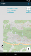
The SNOWHOW-Freeride App offers offline use of maps from the Alps. With an adjustable layer you can check the incline (steepness) of the slopes.
The slope incline is a key parameter for European decision making strategies in wintery and avalanche prone terrain.
The SNOWHOW-Freeride App is no substitute for any other tools of orientation and decision making and necessary safety gear. Shown tracks and map information are not recommendations for any terrain use.
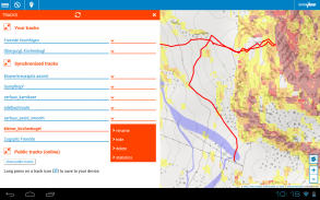
Track recording:
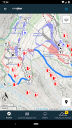
The GPS-function of your phone allows you to find your current position on the map.
Combined with the color coding of the slope incline, you can evaluate the terrain around you.
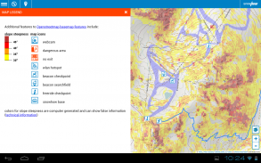
Color coding for incline:
The color coding shows the steepness of the terrain in four sectors.
These sectors are used in decision making strategies in Europe. The knowledge and correct use of decision making strategies (see http://goo.gl/y5Rmx ) is essential to be able to use the SNOWHOW-Freeride App properly. If you are not familiar with any kind of decision making strategies or any other knowledge about decision making in avanlanche prone terrain, do not use the SNOWHOW-Freeride App.
Resolution and color coding:
Each color coded tile shows an area of 10 x 10 metres or real terrain. Keep in mind, that within 10 metres the steepness of a slope can change dramatically.
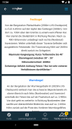
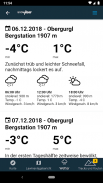
Weather data and Avalanche Bulletin:
If you go online with your smartphone, the SNOWHOW-Freeride App will automatically load the newest avalanche bulletin.
The SNOWHOW-Freeride App menawarkan penggunaan peta secara offline dari Pegunungan Alpen. Dengan lapisan yang dapat disesuaikan, Anda dapat memeriksa kemiringan (kecuraman) lereng.
Kemiringan lereng adalah parameter utama untuk strategi pengambilan keputusan Eropa di medan musim dingin dan rawan longsor.
Aplikasi SNOWHOW-Freeride tidak dapat menggantikan alat orientasi dan pengambilan keputusan lainnya serta peralatan keselamatan yang diperlukan. Trek yang ditampilkan dan informasi peta bukan rekomendasi untuk penggunaan medan apa pun.
Rekaman trek:
Fungsi GPS telepon Anda memungkinkan Anda menemukan posisi Anda saat ini di peta.
Dikombinasikan dengan kode warna kemiringan lereng, Anda dapat mengevaluasi medan di sekitar Anda.
Pengodean warna untuk tanjakan:
Pengodean warna menunjukkan kecuraman medan di empat sektor.
Sektor-sektor ini digunakan dalam strategi pengambilan keputusan di Eropa. Pengetahuan dan penggunaan strategi pengambilan keputusan yang benar (lihat http://goo.gl/y5Rmx) sangat penting untuk dapat menggunakan Aplikasi SNOWHOW-Freeride dengan benar. Jika Anda tidak terbiasa dengan segala jenis strategi pengambilan keputusan atau pengetahuan lain tentang pengambilan keputusan di medan rawan avanlanche, jangan gunakan Aplikasi SNOWHOW-Freeride.
Resolusi dan kode warna:
Setiap ubin kode warna menunjukkan area 10 x 10 meter atau medan nyata. Perlu diingat, bahwa dalam 10 meter kecuraman lereng dapat berubah secara dramatis.
Data cuaca dan Buletin Longsor:
Jika Anda online dengan smartphone Anda, Aplikasi SNOWHOW-Freeride akan secara otomatis memuat buletin longsor terbaru.
snowhow freeride - Versi 2.0.26
(02-11-2021)snowhow freeride - Informasi APK
Versi APK: 2.0.26Paket: info.snowhowVersi Terakhir dari snowhow freeride
Versi lain


Aplikasi pada kategori yang sama


